
|
Africa mainly lies within the intertropical zone between the Tropic of Cancer and the Tropic of Capricorn. Only the northernmost and the southernmost fringes of the continent have a Mediterranean climate because they aren't located under the tropics.
|

|
geography
Africa, the second-largest continent, is bounded by the Mediterranean Sea, the Red Sea, the Indian Ocean, and the Atlantic Ocean. It is divided in half almost equally by the Equator.
Africas physical geography, environment and resources, and human geography can be considered separately.
Africa has eight major physical regions: the Sahara, the Sahel, the Ethiopian Highlands, the savanna, the Swahili Coast, the rain forest, the African Great Lakes, and Southern Africa. Some of these regions cover large bands of the continent, such as the Sahara and Sahel, while others are isolated areas, such as the Ethiopian Highlands and the Great Lakes. Each of these regions has unique animal and plant communities.
The Sahara is the worlds largest hot desert, covering 8.5 million square kilometers (3.3 million square miles), about the size of the South American country of Brazil. Defining Africas northern bulge, the Sahara makes up 25 percent of the continent.
The Sahara has a number of distinct physical features, including ergs, regs, hamadas, and oases. Ergs, which cover 20 percent of the Sahara, are sand dunes that stretch for hundreds of kilometers at heights of more than 300 meters (1,000 feet). Ergs cover most of Algeria and Libya and parts of Mali and Nigeria. Ergs can contain large quantities of salt, which is sold for industrial and food use.
Regs are plains of sand and gravel that make up 70 percent of the Sahara. The gravel can be black, red, or white. Regs are the remains of prehistoric seabeds and riverbeds, but are now nearly waterless.
Hamadas are elevated plateaus of rock and stone that reach heights of 3,353 meters (11,000 feet). They include the Atlas Mountains, which stretch from southwestern Morocco to northeastern Tunisia; the Tibesti Mountains of southern Libya and northern Chad; and the Ahaggar Mountains in southern Algeria.
An oasis is a hub of water in the desert, often in the form of springs, wells, or irrigation systems. About 75 percent of the Saharas population lives in oases, which make up only 2,071 square kilometers (800 square miles) of the deserts vast area.
climate
To describe weather conditions across the continent of Africa in specific terms is difficult in such a small space, so we'll opt for general terms.
Most of Africa is in the tropics, and except for the peaks of mountains in the Great Rift Valley, it never freezes. The continent's northern half is primarily desert or arid, while its central and southern areas contain both savanna plains and very dense jungle (rainforest) regions.
Africa is the hottest continent on earth; dry lands and deserts comprise 60% of the entire land surface. The Sahara Desert (including its satellite deserts) is the world's largest hot desert, and temperature above 37.78 °C (100 °F) are common. In fact, the record for the highest temperature ever recorded was set in Libya in 1922; 58 °C - (136 °F).
To the immediate south of the Sahara Desert in the Sahel region, drought and annual rains way below average are rather common, and major dust storms are a frequent occurrence. In the central African rain forests (along the Equator) warm to hot climate conditions are the norm with very high humidity; Africa's heaviest rains fall in this area.
In the far south, the Kalahari Desert, a large semi-arid sandy savannah covers much of Botswana and parts of Namibia and South Africa. Rainfall is sparse and summer temperatures run high. It usually receives 3–7.5 inches (76–190 mm) of rain each year.
Summers in Southern Africa can be be quite hot, especially along the coastal areas. Inland in the higher elevations, temperatures do moderate. Winters are generally mild, with some light snow in the hills and mountains.
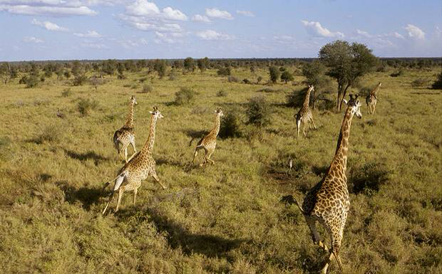
grasslands
When the wildlife of Africa is mentioned, The first things that comes into everybodys' mind are lions, elephants, cheetahs, rhinoceros, zebras, giraffes, antelopes, and so on. All these animals, in fact, are part of a big and complex biome, the grasslands.
The African grasslands are spreading between the east and west sides of the continent, from Senegal and Guinea to the Indian Ocean. They cover the plains of Sudan, Kenya and the valleys of South Africa.
We don't know much about grasslands (in fact we know very little about them), but we know that they are big, wide planes covered mainly by grass, with some trees here and there and some herbaceous, or perennial flowering plants. Some trees are the baobabs, the euphorbias, or spurges, and acacia trees. The trees usually have small leaves, and lots of times, thorny. As mentioned there are hardly any flowering plants on the grasslands. The reason for this is the climate of this biome. Grasslands have two main periods following each other; there is a period where lots of rain falls. After this rainy period or season comes the dry season, whence no rain, or just very little falls for three to eight moths. Since most plants, besides grass, need "constant " rainfall, they would not be able to grow there, so they don't even try. The fact of the dry and muddy soil explanes why most of the organisms there have big bodies, and why a lot of them have hoofs of some sort.
Once, long ago, the grasslands had even much greater diversity of animals than they have today. The grasslands of the Pleistocene era were the most spectacular of all times. These African grasslands had other kinds of rhinoceros, mastodons, elephants, grazing, wild horses, native camels and pronghorns. This era was ended by the ice-age. After the ice age was over the African grasslands weren't the same any more, because most of the animals were killed and some even became extinct. The pronghorns and the native camels, for example did not live there any more, and even the once uncountable number of horses became zebras and a few wild donkeys.
Because of the periodical droughts, the key and the most important life form on the grasslands is grass. Grass is almost the only organisms on savannas (grasslands are also called and referred to as savannas), that stayed there all through the ages. Grass is monocotyledon. Monocotyledons are flowering plants with a single cotyledon. A cotyledon is a struture in an embrio of a seed plant that may form a "leaf" after germination and is commonly known as a seed leaf. Monocotydelons usually have narrow leaves with parallel veins and smooth edges, and hollow or soft stems (just like in the case of grass). Their flower parts are arranged in threes. Back in the dinosaurus' times grass already existed, probably, or something very similar to that. In the Cretaceous Era, as far as we know, grass was mainly tall and semiaquatic, and lived either in swamps or in the shades of the forests. Grasses had such a strong influence on evolution of some mammals that its spread, from the changes in fossil bones and teeth of horses, pronghorns and cattle, can be traced even today. The first known grass is from the Lower Miocene layer, and dates back to about 25 million years. Also it was about this time that the typical skeletal structures of horses started to show up. So, much can be told about the past of the grasslands by studying the remains and fossils of animals that once lived on them.
